Quick Overview
- The cadastral map shows property boundaries, the location of buildings, parcel numbers, protected zones, and other information important when purchasing or inspecting real estate.
- You can search by municipality, parcel number, building number, or case number.
- Before signing a contract, always verify that the area, boundaries, buildings, access road, and restrictions on ownership rights match what is stated in the contract and what you see in reality.
Do you need to be sure that the purchase contract and the information in the land registry match? Let us review your real estate purchase contract before you sign it.
Do you need to quickly verify information about a property, or do you want to be sure there are no legal issues associated with it? Try the ikatastr.cz website, where you can check for free who owns the land and what its boundaries are. Thanks to the land registry and free access to its records, you can find out everything you need to know online—from ownership and restrictions on property rights to property boundaries. Accessing the land registry is easy, fast, and available to everyone.
What is the real estate cadastre and the cadastral map?
The Land Registry is a public register that records ownership and other real rights to real estate. By accessing the Land Registry, you can obtain information about property owners, restrictions on ownership rights, or surveying data on parcels of land. Online access to the land registry allows you to easily find the information you need at no cost. The ikatastr website also offers easy access, enabling clear searches directly on the map.
The cadastral map can be accessed in the Land Registry. While the cadastral map used to be available only in physical, printed form—so-called “analog”—today you can search digital maps, which are available for free on the website of the Czech Office for Surveying, Mapping, and Cadastre.
An available attorney advises: “Digitization has not yet been completed throughout the entire territory of the Czech Republic, so some areas (especially in rural areas) may not be geometrically accurate on the cadastral map. In such cases, you can use the services of companies that create orthophoto maps or rely on the traditional method of visiting the land registry office in person.”
We know from experience that it is precisely these minor inaccuracies in property boundaries that tend to be the source of neighbor disputes. For example, a client may believe that a fence stands exactly on the parcel boundary, but a more detailed comparison of the map, the orthophoto map, and the actual survey reveals that part of the fence or the driveway encroaches on the neighboring property. The cadastral map is therefore an excellent first step, but for more expensive properties or unclear boundaries, it does not replace a legal and technical review.
What is shown on the cadastral map?
- state borders,
- boundaries of local government units,
- property boundaries,
- boundaries of protected areas,
- boundaries of protection zones,
- building perimeters,
- other features—tunnels, bridges, access roads.
Online Land Registry: How to Access It for Free?
Online access to the Land Registry is a free service that allows you to view basic information about properties. Unlike a Land Registry extract, which is subject to a fee, you can obtain an overview of ownership and restrictions on rights for free. You can access the online Land Registry on the website of the Czech Office for Surveying, Mapping, and Cadastre.
Searching the land registry allows you to quickly find information about area, boundaries, ownership rights, and any restrictions. Free online access to the land registry is available to everyone and lets you check for buildings, protected areas, or restrictions on ownership rights.
Searching the Land Registry—How to Find Your Property?
When searching the cadastre online, enter the name of the municipality, the parcel number, or the house number into the cadastre search engine. The system will allow you to zoom in on a specific parcel and view its detailed information. Consulting the land registry is useful, for example, when purchasing real estate or resolving disputes over property boundaries.
When buying real estate, don’t rely solely on a quick online search. If you see any restrictions on ownership rights, easements, liens, or unclear access to the property in the cadastre, we recommend having the contract and title deed reviewed by an attorney before you pay the reservation fee.
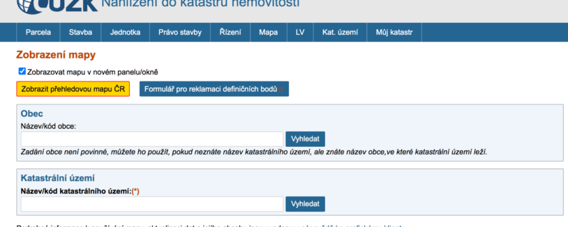
You can easily access cadastral maps through the Land Registry viewing page. Enter the name of the cadastral area, which corresponds to the name of the largest municipality. The system accounts for multiple municipalities with similar names and always offers all possible options, distinguishing between districts. You will then see a map of the cadastral area, where you can zoom in on the location you’re looking for until the parcel number is displayed.
Tip for article
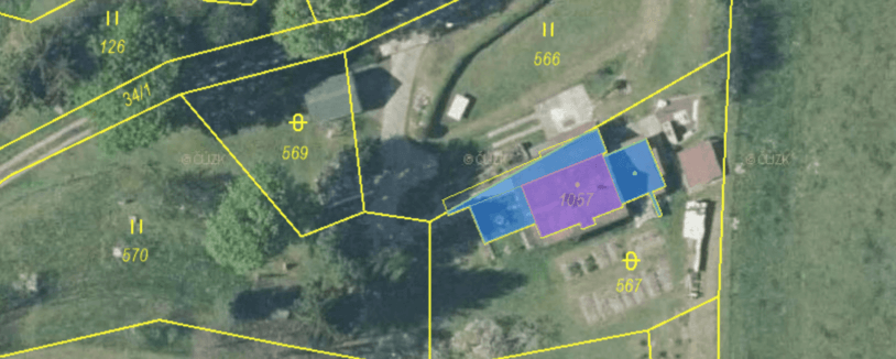
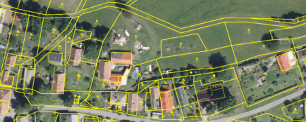
Tip: Try switching to the more user-friendly orthophoto map, which lets you view an aerial photo of the area alongside the cadastral map.
However, if you have more information about the property, you can use the menu at the top of the cadastral map to find it more quickly by entering the parcel number, building number, or case number.
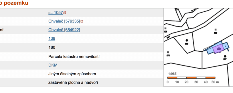
An attorney explains:“For example, we tried to locate a parcel of land in the village of Chvaleč, where we knew the property registration number. Instead of using the overview cadastral map, we used the building’s registration number and were taken directly to the detailed information. The overview shows not only the owner, but also the specific type of parcel, its area, and any restrictions on ownership rights.”
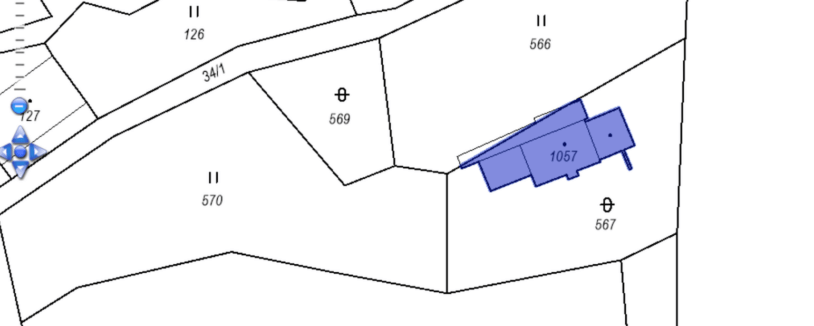
After clicking on the map, it’s best to work directly with the cadastral map, which allows you to view the boundaries of the parcel and the buildings themselves, as well as the parcel and building numbers. For a better overview and verification, you can use the orthophoto map mentioned above at this point. The cadastral land map will then look like this:
Tip for article
Tip: Don’t forget to click the KN button (property information) at the bottom; when you hover your cursor over it, all the important details about the property will be displayed.
8-Point Checklist: What to Check in Cadastral Maps Before Signing a Purchase Agreement
- Verify that the correct land area is listed for the property in the purchase agreement.
- Check the property details to ensure there are no restrictions on ownership rights, or that any such restrictions match what is stated in the contract. The most common mistake we see in real estate transactions is underestimating the significance of notes and restrictions listed on the title deed. Buyers verify the owner’s name but often overlook liens, easements, prohibitions on alienation, or ongoing legal proceedings. Yet it is precisely this information that can significantly affect whether the purchase is secure and whether the bank will approve financing.
- Check the cadastral map for any structures registered on the property and compare the recorded status with the actual situation on the ground.
- Be sure to check whether there are any unauthorized structures on the property that are not marked on the map and therefore have not been approved for occupancy.
- Check to see if any structures encroach on neighboring property.
- Verify that you will have accessible access to the property via municipal land or public roads, or that an easement has been established across another party’s land. In practice, we have handled cases where the buyer only discovered after signing the contract that the access road ran across private land and the easement had not been registered in the land registry. Such a situation is difficult to rectify—the new owner must negotiate with the neighbor or, if necessary, seek a resolution through the courts. Therefore, always verify access to the property before signing the contract, not only by consulting the map but also by reviewing the title deed and the contractual documentation.
- Compare the building’s floor plan with the actual layout. In practice, it sometimes happens that owners, for example, fail to report or register an addition on the cadastral map, and the floor plan on the cadastral map then looks completely different.
- For sheds, terraces, or outbuildings , verify that they are marked as structures (a line with a dot in the middle) in the land registry and thus on the map. However, it’s important to keep in mind that the gradual digitization of the cadastral map may have led to minor discrepancies. Therefore, focus instead on the size and shape of the building.
For a complete overview of the land registry, you can use the online land registry portal. When verifying the information, we recommend checking whether the details listed in the purchase agreement match the data in the land registry.
Are you solving a similar problem?
Proposal for entry into the Land Registry
Measure twice, cut once. That goes for official filings as well. Enrolment in the Land Registry is a formality, but a very important formality that is not to be underestimated. Do you need to register an easement in the Land Registry? Or a lien so you don’t lose the money you borrowed?
I want to help
- When you order, you know what you will get and how much it will cost.
- We handle everything online or in person at one of our 6 offices.
- We handle 8 out of 10 requests within 2 working days.
- We have specialists for every field of law.
What other information can you find on cadastral maps?
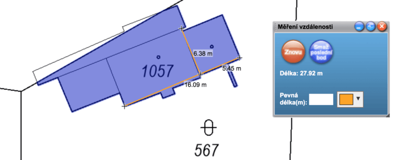
- Measuring distances on a cadastral map—click the icon with numbers to measure distances, as shown in our image.
Then, simply use the left cursor to select the two points you want to measure—whether it’s the length of the lot, its width, the distance of the building from the access road, or the distance to the nearest neighbor.
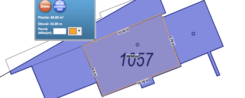
- Measuring a building —you can use the same method for a building. This will easily tell you the approximate length and depth of the building.
- Measuring Area – By marking all the corners, you can determine the area of any parcel. The same method works as in the previous example with a building.
The list of features offered by the cadastral map doesn’t end there. For experts, the digital version offers additional functions, such as the ability to add layers showing parcel boundaries with accuracy specifications, point location fields, map sheet references, and other details. If you’re interested in this information, you can use the help section for viewing the cadastre directly on the ČÚZK website.
Of course,the Real Estate Cadastre allows you to print the map or download it as a PDF file.
Is the map detail not enough for you, and do you need an official extract? Find out the difference between an extract from the Real Estate Cadastre and a search, how much it will cost you, and what to watch out for. We’ve covered all the essentials in our next article.
Using the iKatastr online tool or the Land Registry portal, you can quickly and free of charge verify important information about any property—from ownership, area, and legal restrictions to the boundaries of parcels or buildings. The cadastral map also shows buffer zones, protected areas, and other geographic features. The digital cadastral map allows for easy searches by parcel number, descriptive number, or municipality name. In addition, you can switch to an orthophoto map for better orientation on the ground. When purchasing real estate, we recommend conducting an eight-point data check—including verification of ownership rights, the actual condition of structures, and access to the property. If you discover any discrepancies, it may be necessary to file a petition for registration in the real estate cadastre.
A final tip—not just for architects:
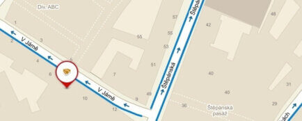
Do you live in Prague? Thanks to the Dvě Prahy app, you can compare what your street looked like 80, 60, 40, and 20 years ago. It’s an easy way to explore the history of a specific place and see how its appearance has changed over time.
Are you about to sign a purchase agreement? Send it to us for review. We’ll verify that the property details match the land registry, that the parcels and buildings are correctly described, and that the agreement addresses risks that are often overlooked in practice.
Summary
The Land Registry is a public registry that records ownership and real rights to real estate, available online for free through portals such as ikatastr.cz or by accessing the Land Registry. The digital cadastral map includes the boundaries of parcels, buildings, territorial units, protected areas, and other features, and allows for quick searches by municipality, parcel number, or building number. Although digitization is not yet complete in all regions, the tool also offers orthophoto maps for better orientation on the ground. When purchasing real estate, it is essential to verify eight key points: the accuracy of the land area, the absence of restrictions on ownership rights, the actual condition of buildings, access to the property, and compliance with the purchase agreement. Online tools are available for measuring distances or areas. In the event of discrepancies, it is necessary to file a request for entry in the land registry.
Frequently Asked Questions
Is the cadastral map legally binding?
The Real Estate Cadastre is a public registry, but the map itself may not always accurately reflect the actual course of the boundaries on the ground. In cases of disputed boundaries, it is advisable to conduct a survey and seek a legal assessment.
Can I tell from the land registry that there is a mortgage on the property?
Yes, the bank’s lien is usually listed on the title deed. When purchasing a property, it is important to verify how the lien will be removed and whether the procedure is properly addressed in the purchase agreement.
What does an easement on a parcel of land mean?
An easement can, for example, involve a right of way, the right to run utility lines, or the right of another person to use the property for life. Before purchasing, you need to find out whom the easement protects and how it will restrict you as the new owner.
What should you do if a building isn't shown on the cadastral map?
First, verify whether the structure is one that is required to be registered in the land registry. If so, the problem may lie with the construction documentation, the final inspection, or the land registry entry. When purchasing such a property, we recommend a legal review.
How can I find out if a property has legal access?
A map will show you the physical route of the path, but you can only verify legal access by checking the ownership of neighboring properties and any easements. It is not enough for the path to simply exist on the ground.